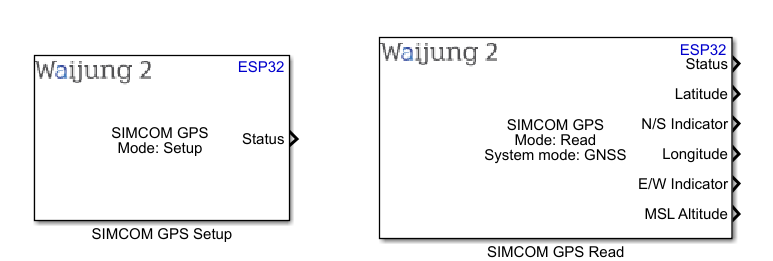
How this block appears in a Simulink model?
What can be configured?
SIMCOM GPS Setup
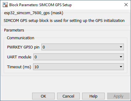
Configuration Parameter |
Selectable Option/Value |
Description |
POWERKEY GPIO pin |
0-36 |
Select the POWERKEY gpio pin to turn on the module |
UART module |
0-2 |
Select the UART module. UART module will be listed according to the available blocks of UART setup blocks |
Timeout |
10--100--1000 |
Timeout for the UART communication |
OUTPUT Port
Port Name |
Port Type |
Date Type |
Description |
Status |
Scalar |
uint32 |
Status output port |
SIMCOM GPS Read
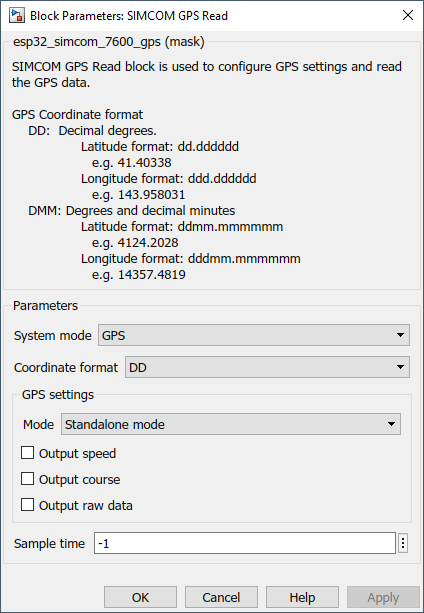
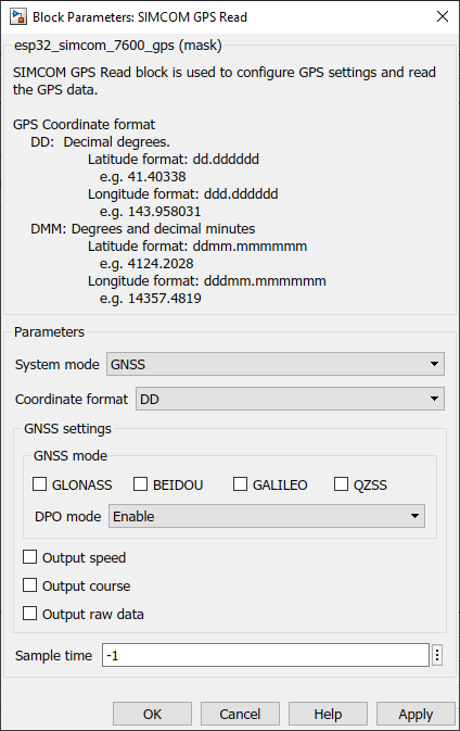
Configuration Parameter |
Selectable Option/Value |
Description |
System mode |
GPS--GNSS |
Select the system mode |
Coordinate format |
DD--DMM |
GPS Coordinate format DD: Decimal degrees Latitude format: dd.dddddd e.g. 41.40338 Longitude format: ddd.dddddd e.g. 143.958031 DMM: Degrees and decimal minutes Latitude format: ddmm.mmmmmm e.g. 4124.2028 Longitude format: dddmm.mmmmmm e.g. 14357.4819 |
Mode |
Standalone mode--UE based mode--UE assisted mode |
|
GLONASS |
check--uncheck |
Enable/Disable GLONASS Satellite |
BEIDOU |
check--uncheck |
Enable/Disable BEIDOU Satellite |
GALILEO |
check--uncheck |
Enable/Disable GALILEO Satellite |
QZSS |
check--uncheck |
Enable/Disable QZSS Satellite |
DPO mode |
Enable--Disable |
Enable/Disable DPO in GNSS |
Output course |
check--uncheck |
Output the course data |
Output raw data |
check--uncheck |
Output the raw data from the gps module |
Sample time |
-1(inherited) or specify |
Specify the sample time |
OUTPUT Port
Port Name |
Port Type |
Date Type |
Description |
Status |
Scalar |
uint32 |
Status output port |
Latitude |
Scalar |
double |
This will output the Latitude |
N/S Indicator |
Vector |
uint8 |
Outputs N/S Indicator |
Longitude |
Scalar |
double |
This will output the Longitude |
E/W Indicator |
Vector |
uint8 |
Outputs E/W Indicator |
MSL Altitude |
Scalar |
double |
This will output the mean sea level altitude |
Speed |
Scalar |
double |
This will output the Speed |
Course |
Scalar |
double |
This will output the Course |
Raw data |
Vector |
uint8 |
This will output the raw data from the GPS module |
When to use this block?
This block can use to setup the GPS connection. Using SIMCOM GPS Read, GPS/GNSS data can be read. It is mandatory to have a setup block when using GPS Read block.
How does this block work?
•SIMCOM GPS Setup: Use to set up the GPS connection
•SIMCOM GPS Read: Use to get the GPS data